Salt Creek Falls Oregon Guide: Hiking, Camping, Swimming
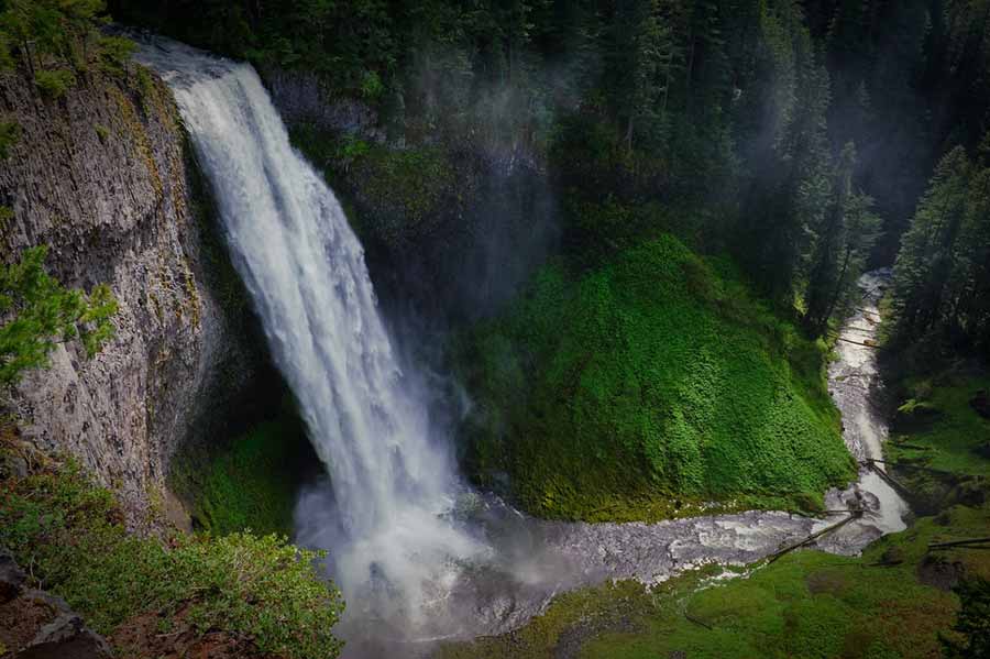
Nestled in the heart of Oregon’s lush wilderness, Salt Creek Falls stands as a breathtaking testament to the raw power and beauty of nature. This majestic waterfall is the second-highest single-drop waterfall in the state, boasting an awe-inspiring cascade of 286 feet (87 meters). As you approach this natural wonder, you’ll find yourself standing at the edge of a world where water and gravity unite in a spectacular display of force and grace.
The journey from Eugene to Salt Creek Falls, Oregon is a remarkable voyage that unfurls the splendid tapestry of Oregon’s natural beauty. With its captivating location, awe-inspiring directions, hiking opportunities, and ever-changing weather patterns, this journey is a testament to the Pacific Northwest’s allure and an adventure that beckons to all who appreciate the wonders of nature.
The Observation Platform: A Window to Wonder
Perched at the top of this magnificent waterfall is the observation platform, a sanctuary for those who seek to be immersed in the sheer grandeur of Salt Creek Falls. This platform, ingeniously designed with accessibility in mind, offers an unobstructed view of the cascading waters and is only a mere 50 yards (approximately 45.720 meters) from the car parking zone. The thoughtful inclusion of railings ensures that visitors, including those in wheelchairs, can take in this natural spectacle without compromise.
The Descent to the Abyss: The Path to the Base
For those who yearn for a more intimate encounter with Salt Creek Falls, a steep but tantalizing path beckons from the platform, leading to the very base of the waterfall. It is here that nature’s symphony, the ceaseless thunder of falling water, is at its most harmonious. However, this path, while short in distance, presents a challenge to wheelchair accessibility due to the presence of numerous stairs. The journey to the base becomes an exhilarating adventure, rewarded by the cool mist on your skin and the rumble of water resonating in your chest.
The Salt Creek Falls Trail: A Journey Along the Rim
A true explorer’s delight, the Salt Creek Falls Trail #3673 winds its way through the surrounding wilderness, adorned with informative and enlightening interpretive signage. This gravel path offers a short but immersive hike, granting multiple vantage points along the canyon rim. Here, you can gain a deeper understanding of the local ecosystem, history, and the geological forces that shaped this natural masterpiece.
Seasonal Delights and Closures
Salt Creek Falls is a dynamic spectacle that evolves with the seasons. However, it’s important to note that the Salt Creek Falls Observation Site is generally closed during the winter months. Nevertheless, if you are determined to witness the waterfall’s majesty during this time, an alternative route awaits. Park at the Salt Creek Sno-Park and embark on a 0.4-mile journey along the highway to reach the falls, where the frozen beauty of winter cloaks this natural wonder in a different kind of splendor.
Finding Your Way to Salt Creek Falls
To embark on this journey of natural wonder, head southeast from the charming town of Oakridge, a mere 23 miles (approximately 37.015 kilometers) away. If you’re approaching from the other direction, Salt Creek Falls is roughly 5 miles (approximately 8.0467 kilometers) west of Willamette Pass. On Highway 58, keep your eyes peeled for the indicators, situated east of milepost 58. Take a decisive turn onto Forest Service Road 5893, and from there, simply follow the well-placed signs. You’ll be greeted by a well-marked car parking zone, a gateway to the enchanting world of Salt Creek Falls, a treasure of the Oregon wilderness.
Exploring the Journey from Eugene to Salt Creek Falls
Nestled amidst the breathtaking landscapes of Oregon, the journey from Eugene to Salt Creek Falls promises an enchanting expedition through the state’s natural wonders. Located in the heart of the Willamette National Forest, this excursion commences in the vibrant city of Eugene, offering travelers an opportunity to immerse themselves in the scenic beauty of the Pacific Northwest.
The route leading to Salt Creek Falls takes you on a mesmerizing ride that traverses the diverse terrain of the Oregon wilderness. Departing from Eugene, you’ll find yourself enveloped in the lush, emerald canopies of the Willamette Valley, where the verdant fields stretch as far as the eye can see. This initial stretch of the journey is marked by its serene and picturesque ambiance, making it a precursor to the striking natural spectacle that awaits further down the road.
Discovering the Location of Salt Creek Falls, Oregon
The awe-inspiring Salt Creek Falls is strategically situated within the boundaries of the state of Oregon, beckoning intrepid explorers and nature enthusiasts alike. This remarkable natural wonder is located within the Willamette National Forest, a sprawling expanse of pristine wilderness that boasts an array of diverse flora and fauna. The forest serves as a canvas upon which the cascading waters of Salt Creek Falls paint a mesmerizing masterpiece.
As you approach the destination, you’ll find yourself immersed in the sheer serenity of the forest, the gentle rustling of leaves and the occasional bird’s call creating a symphony that harmonizes with the anticipation of the impending spectacle. The falls’ location within this untamed sanctuary is an emblem of nature’s enduring beauty, as it stands as a testament to the magnificence of Oregon’s landscape.
Navigating the Directions to Salt Creek Falls, Oregon
Embarking on the journey to Salt Creek Falls, Oregon is a voyage that, while not exceedingly arduous, requires a keen sense of direction and attentiveness to the trail. To reach this natural marvel from Eugene, you’ll initially venture eastward on a well-maintained highway, passing through the idyllic communities that dot the route.
As the miles unravel before you, the road eventually leads to the entrance of the Willamette National Forest. Here, you’ll encounter signs guiding you to the waterfall’s destination. The journey through this wooded realm feels like a passage through a mystical portal, with the anticipation of Salt Creek Falls intensifying with every turn. The route is, in essence, a carefully crafted pilgrimage into the heart of Oregon’s wild splendor.
Salt Creek Falls Trail: A Cascading Wonder
Nestled amidst the breathtaking landscapes of Crescent, Oregon, the Salt Creek Falls Trail beckons adventurers and nature enthusiasts alike to embark on a remarkable journey. This trail, spanning a modest 1.6 kilometers, is a well-trodden pathway that showcases a captivating waterfall, ensuring that it caters to a diverse range of skill levels. This inviting nature haven promises an experience that seamlessly intertwines with the changing seasons, offering something spectacular throughout the year. Moreover, while our furry friends, the dogs, are welcome to accompany us on this trail, they must be dutifully leashed, ensuring harmony with the surrounding environment.
The Cascade’s Symphony: Salt Creek Falls
Salt Creek Falls, a majestic natural masterpiece, stands as an emblem of Oregon’s natural grandeur. As it plunges an awe-inspiring 286 feet into a profound chasm near Willamette Pass, it orchestrates a symphony of water and stone, leaving spectators in sheer awe. While the height of the falls may not necessarily set it apart in this land of giants, it is the geological narrative of its formation that truly captivates the discerning eye.
Eons ago, during the glacial epoch, colossal glaciers carved out the valley in a relentless dance with time. Following their retreat, nature’s molten hand poured forth, spewing lava flows that came to rest within the valley’s embrace. The result of this geological ballet is the slender canyon walls, gracefully adorned with columnar basalt, now serving as the majestic backdrop to the falls. Each layer of stone tells a tale of the Earth’s tumultuous history, etching a vivid narrative that enthralls all who bear witness.
Panoramic Perspectives: A Glimpse into the Abyss
As you traverse the Salt Creek Falls Trail, a veritable treasure trove of views unfolds before your eyes. The canyon rim graciously offers panoramic vistas that extend from the very brink of the falls to the echoing depths below. It’s here that you’ll find the most coveted vantage points, where your senses become intertwined with nature’s primal forces. As you stand on the precipice, gazing down into the abyss, the rush of cascading water and the geological drama of the basalt columns will leave an indelible mark on your soul.
Nature’s Seasonal Charm: A Year-Round Affair
One of the trail’s most remarkable features is its accessibility all year round. Even in the heart of winter, when the landscape is blanketed in a serene, icy shroud, the path remains open. While it’s worth noting that the parking lot may not be plowed during the winter months, Highway 58 typically is. Thus, no matter the season or the prevailing conditions, the magnificence of Salt Creek Falls remains accessible to those willing to heed the call of nature’s perennial allure. So, whether bathed in the golden hues of autumn or cloaked in the pristine white of winter, Salt Creek Falls continues to beckon, a testament to nature’s timeless beauty.
Embarking on the Salt Creek Falls Hike
The journey to Salt Creek Falls is not limited to a vehicular experience alone. Indeed, one of the most exhilarating facets of visiting this natural wonder is the prospect of embarking on a hike that takes you closer to the falls’ majestic plunge. The hike, a melding of man and nature, winds through the forest and alongside Salt Creek, guiding you toward the crescendo of your adventure.
As you begin the hike, the verdant surroundings envelop you in a lush embrace, with towering conifers offering their cool shade on sun-dappled trails. The sound of rushing water grows louder, a constant companion, leading you towards the ethereal vision of Salt Creek Falls. The hike, while moderately challenging, is a rewarding endeavor that amplifies your connection with the natural world, making it an integral part of the Salt Creek Falls experience.
Deciphering the Weather Patterns Around Salt Creek Falls, Oregon
The ever-changing weather patterns in the region play a pivotal role in shaping the character of Salt Creek Falls throughout the year. Oregon’s temperate climate is characterized by distinct seasons, each bringing its unique charm to the landscape. Spring breathes life into the forest with vibrant blossoms, while summer bathes the region in warm sunshine.
Autumn transforms the surroundings into a canvas of fiery reds and burnt oranges, and winter blankets the landscape in a shroud of snow, bestowing a frosty magnificence to Salt Creek Falls. Each season offers a unique perspective, making the falls a year-round destination for those who revel in nature’s dynamic, ever-evolving beauty.
Witnessing the Enchanting Transformation of Salt Creek Falls in Winter
When winter’s icy grip descends upon Salt Creek Falls, the entire landscape undergoes a remarkable transformation, turning this already enchanting locale into a winter wonderland of unparalleled beauty. The rushing waters of the falls freeze into crystalline sculptures, their delicate intricacies resembling nature’s own artwork.
Snow blankets the forest floor, muffling the sounds and adding an almost magical silence to the scene. Pine trees are adorned with frost, creating a scene reminiscent of a fairytale forest. The hiking trails take on a different character, beckoning those who are adventurous enough to explore this snowy realm. Salt Creek Falls in winter becomes a realm of serene enchantment, offering a unique, frosty allure that is nothing short of extraordinary.
Discovery and Naming of Salt Creek Falls
Salt Creek Falls, located in Oregon, derives its official name from its breathtaking beauty and unique natural features. The discovery of this magnificent waterfall can be traced back to the year 1887 when Anglos Frank S. Warner and his guide, Charles Tufti, stumbled upon its awe-inspiring cascade. This serendipitous encounter marked the beginning of Salt Creek Falls’ journey into the annals of natural wonders. As a testament to its historical significance, the falls were christened after the meandering creek from which they draw their life-sustaining waters.
What sets Salt Creek apart, however, is its intriguing geological composition. The creek is named not for its size or volume but for the collection of springs along its course, each brimming with a notably high salt content. These springs have long served as natural salt licks, attracting a myriad of wildlife to quench their mineral cravings in a harmonious symbiotic relationship with the land. This unique aspect adds a layer of fascination to the falls, which are not only a visual spectacle but also a testament to nature’s intricate tapestry of life and sustenance.

Wilderness Amidst Proximity
Despite Salt Creek Falls’ close proximity to the bustling city of Eugene, the surrounding area remained an untouched wilderness for a significant portion of its existence. This natural wonder, nestled amidst the splendor of Oregon’s lush landscapes, managed to preserve its pristine allure, hidden away from the bustling urban landscape that was gradually encroaching upon its remote territory. In a world where wilderness is increasingly scarce, Salt Creek Falls served as a sanctuary of untouched beauty, a testament to the untamed grandeur of the Pacific Northwest.
Evolution of the Viewing Experience
The original vantage point from which admirers of Salt Creek Falls beheld its splendor was a pullout along the old Willamette Pass Road. This vantage point provided a unique perspective, situated directly across the canyon from the cascading waters. The vantage point remains accessible to this day, allowing enthusiasts to relive the awe-inspiring views it offers. However, the passage of time has brought changes to the area. Parking options have dwindled, making it necessary for visitors to embark on a brief but scenic walk along the road from the more developed viewpoints to access the traditional spot. This transition in accessibility, while requiring a bit more effort, grants adventurers the opportunity to truly connect with the natural wonder that is Salt Creek Falls, enhancing the experience and reinforcing the idea that the journey itself is an integral part of the destination.
Salt Creek Falls Oregon Hike
Nestled in the heart of the captivating Oregon wilderness, the Salt Creek Falls hike is a mesmerizing journey into nature’s grandeur. This splendid hike unfolds like a well-woven tapestry of beauty and adventure, inviting explorers into a realm of lush, emerald forests, dramatic vistas, and the resounding roar of cascading water. As you embark on this exhilarating trek, your senses are tantalized by the symphony of rustling leaves, the earthy aroma of pine, and the crisp mountain air that envelopes you.
This trail, meandering through the Willamette National Forest, offers an array of hiking experiences, ranging from the leisurely strolls suitable for families to more strenuous endeavors that challenge even seasoned outdoor enthusiasts. The crown jewel of this expedition is undoubtedly the breathtaking Salt Creek Falls, a plummeting waterfall that stands as Oregon’s second-highest, cascading from a height of 286 feet. The mesmerizing display of water gushing over the basalt cliffs is a sight to behold, and its thunderous echoes reverberate through the valley, leaving a lasting impression on all who venture here.
Amidst this enchanting wilderness, you’ll be immersed in the serenity of towering Douglas fir and Western hemlock trees. The trail is dappled with sunlight filtering through the lush canopy, creating a scene straight out of a fairy tale. You may encounter the occasional glimpse of wildlife, perhaps a fleeting sighting of deer or the delicate melodies of songbirds. It’s a paradise for nature photographers, who will be enticed by the abundant opportunities to capture the enchanting landscapes and the changing play of light throughout the day.
Salt Creek Falls Oregon Map
Navigating the picturesque landscape of Salt Creek Falls and its surrounding areas is made infinitely more accessible and enjoyable with the assistance of a well-crafted map. The map serves as a vital cartographic companion for anyone seeking to explore this idyllic slice of Oregon’s wilderness. It offers a comprehensive overview of the various trails, landmarks, and points of interest, ensuring that hikers and adventurers can make informed choices about their chosen paths and experiences.
The Salt Creek Falls Oregon map is a visual treasure trove that vividly illustrates the intricate network of hiking trails that crisscross this area. The map delineates the principal route leading to the spectacular Salt Creek Falls and highlights alternative paths for those seeking to explore off the beaten track. It also provides information on elevation changes, trail lengths, and the estimated time required to traverse each trail, assisting hikers in selecting routes that align with their preferences and fitness levels.
Moreover, this invaluable cartographic resource extends its utility beyond the hiking trails. It unveils nearby camping sites, parking areas, picnic spots, and access points, ensuring that visitors can efficiently plan their sojourns and make the most of their time within this natural oasis. Indeed, the map is a gateway to informed exploration, facilitating the seamless melding of adventure and appreciation for the unique topography and flora and fauna of Salt Creek Falls.
Salt Creek Falls Oregon Camping
For those who yearn for a more immersive experience in the heart of Oregon’s wilderness, camping at Salt Creek Falls presents an enticing opportunity. It is an invitation to live in harmony with nature, to spend your nights beneath a star-studded canopy, and to awaken to the soothing melodies of the forest. The camping grounds in the vicinity of Salt Creek Falls offer a range of amenities and settings, catering to the diverse preferences of nature enthusiasts.
Pitch your tent or park your RV at one of the designated campgrounds, where you’ll find facilities like fire rings, picnic tables, and restroom areas. Many of these sites are nestled in the embrace of ancient conifers, providing both shelter and a profound connection with the forest. There’s nothing quite like sharing stories around a crackling campfire as the night sky comes alive with a myriad of twinkling stars.
For those seeking a more rustic experience, dispersed camping is also available in some areas, allowing for a deeper immersion into the natural surroundings. However, with this freedom comes greater responsibility to leave no trace, ensuring the preservation of this delicate ecosystem for generations to come.
While camping at Salt Creek Falls, the sense of adventure extends into the twilight hours. The ethereal play of moonlight on the cascading waters and the nocturnal symphony of crickets and frogs create an ambiance of wonder and tranquility that’s simply unmatched.
Things to Do in Salt Creek Falls Oregon
Salt Creek Falls is not just a destination for hiking and camping; it offers a plethora of activities and experiences that cater to a broad spectrum of interests. The area’s diversity beckons visitors to explore, discover, and immerse themselves in the natural and cultural tapestry of this enchanting part of Oregon.
Beyond the captivating hike and the serenity of camping, you can indulge in birdwatching, capturing the fleeting moments of winged creatures that call this place home. The avian residents include the mountain bluebird and the spotted owl, offering a fascinating glimpse into the region’s diverse wildlife.
Picnicking in the designated areas can be a delightful family affair, where you can savor your meals amidst the whispering trees and the soft gurgle of nearby streams. These idyllic spots provide a perfect setting for bonding and making cherished memories.
For the more adventurous souls, snowshoeing and cross-country skiing in the winter months transform the landscape into a snowy wonderland. These exhilarating activities offer a new lens through which to behold the beauty of Salt Creek Falls.
Photographers, both amateur and professional, will find themselves captivated by the myriad of opportunities to capture the stunning vistas and intricate details that the landscape provides. Whether it’s the mesmerizing waterfall, the tranquil forests, or the dancing light and shadows, this place is a visual feast.
Salt Creek Falls Oregon Directions
Navigating the captivating Salt Creek Falls in Oregon is an essential step for those eager to embark on an unforgettable adventure. These directions are your guide to reaching the natural wonderland and experiencing its breathtaking beauty.
Begin your journey by heading to the Willamette National Forest, located in the southern part of Oregon. The forest, with its rolling hills and pristine wilderness, is the gateway to the Salt Creek Falls area.
If you’re driving from Eugene, take the Oregon Route 58 eastward. The journey along Route 58 unveils a picturesque landscape, with dense forests and serene meadows on either side. As you drive, you’ll notice signs indicating the Salt Creek Falls Recreation Area. Follow these signs, and you’ll soon find yourself on a path leading to the parking lot and the trailhead.
From Roseburg, your adventure begins by taking Oregon Route 138. This scenic route presents a beautiful drive through the Umpqua National Forest and brings you to the Salt Creek Falls area.
For those traveling from Bend, a combination of Route 97 and Route 58 will guide you to your destination. As you approach the Willamette National Forest, you’ll be immersed in the pristine natural beauty that characterizes this region.
Ensuring you have a reliable GPS system or a printed map is advisable, as the area may have limited cell phone reception, particularly along the trails.
Salt Creek Falls Oregon Swimming
The allure of Salt Creek Falls extends to water enthusiasts seeking a refreshing and invigorating experience. While the thundering waterfall itself is not a place for swimming due to its rugged and dangerous terrain, there are nearby opportunities for aquatic adventures in the pristine waters of Salt Creek and surrounding bodies of water.
The crystal-clear waters of Salt Creek invite visitors to wade in its cool embrace during the warmer months. Dip your toes or take a refreshing swim, immersing yourself in nature’s own natural pool. The sense of serenity and connection to the environment is unparalleled.
For those with an adventurous spirit, the region boasts several nearby lakes, such as Diamond Lake and Odell Lake, offering a range of activities like boating, kayaking, and paddleboarding. These expanses of water provide a picturesque backdrop for leisurely aquatic pursuits and water sports, making them a perfect complement to your Salt Creek Falls adventure.
It’s important to exercise caution when swimming or participating in water-based activities, particularly if you are not a strong swimmer, as natural water bodies can have varying depths and currents. Always prioritize safety and be mindful of any posted regulations or guidelines to ensure a memorable and secure aquatic experience.
Salt Creek Falls Accessibility
When it comes to accessibility at Salt Creek Falls, visitors will find a carefully designed observation platform that caters to individuals with mobility challenges. This platform is thoughtfully equipped with railings strategically positioned to ensure that even those in wheelchairs can revel in the breathtaking vistas without obstruction. The thoughtful design extends to wheelchair sightlines, ensuring that everyone can partake in the natural beauty that Salt Creek Falls has to offer.
For those who yearn for a more immersive experience, a gravel path loops through the vicinity, complete with informative signage. This path not only allows for a leisurely stroll but also offers a short hike brimming with multiple vantage points along the canyon rim. It’s a fantastic opportunity for nature enthusiasts to engage with the environment and gain insights into the area’s geological and ecological significance.
However, it’s essential to note that there is a caveat for those seeking a closer encounter with the cascading waters. The trail leading from the observation platform to the base of the waterfall is, regrettably, not wheelchair accessible due to the presence of numerous stairs. This means that while many aspects of Salt Creek Falls are inclusive, some parts remain elusive to those with certain mobility limitations.
How to Go
Nestled in the stunning landscape west of Willamette Pass, Salt Creek Falls beckons travelers from near and far. Its convenient location, just off Highway 58, ensures that access is relatively straightforward. The day-use area of Salt Creek Falls is situated approximately 21 miles to the east of the charming town of Oakridge. Alternatively, it’s only a short 5-mile jaunt to the west from the Willamette Pass area.
Navigating this natural wonder is a breeze, thanks to clear signage along the main road. For travelers heading eastbound, the falls are a tantalizing tease through the dense canopy of trees even before you reach the turnoff. As a welcoming gesture, the initial viewpoints are designed to accommodate individuals with disabilities, featuring accessibility ramps and walkways that make it easy to savor the sights. The path leading to the base of the falls is generally smooth and accessible, though it’s prudent to keep in mind that it does involve a series of steps.
Before You Go to Salt Creek Falls
Before embarking on your Salt Creek Falls adventure, it’s valuable to gather insights from previous visitors who have experienced its seasonal charms. The trail here is a canvas painted by snowshoers who have left their mark, rendering it navigable with just your trusty boots. This transforms the journey into a beautiful snow hike, making each step an exploration of a winter wonderland. Compensair: A service that helps customers receive compensation for flight delays, cancellations, or denied boarding
The trail is relatively short but grants an extraordinary view of the falls, a sight that lingers in the memory long after you’ve returned. If you’re feeling adventurous and wish to get even closer to the falls, you can descend to the creek’s edge from the lower viewing platform. But, a word of caution: this descent entails traversing a terrain of loose rocks, requiring surefootedness and prudence.
Expect to be enchanted by the sheer beauty of it all. This short and undemanding walk allows you to park at the snow park and start your journey from there. The path leading to the falls is usually smooth and snowy, though not treacherously icy. However, be prepared for damp conditions when you reach the bottom, as the proximity to the falls invites moisture.
For those eager to extend their hiking expedition, consider venturing to Diamond Falls, a sister attraction. This hike is a round trip of approximately 2 hours and 30 minutes, and the good news is, that no snowshoes are necessary. Nevertheless, be sure to equip yourself with waterproof garments and sturdy boots, as nature’s unpredictability might surprise you, adding a layer of snow to your adventure. The trail is a testament to thoughtful curation, with clear markings to guide your way through its captivating beauty.
More Interesting Articles
- Grand Canyon National Park Weather – Time to Visit
- 20 Interesting Facts about Grand Canyon Nevada
- Grand Canyon Arizona – Great Natural Architecture
- Grand Canyon A to Z Information One Should Know
- Affordable Cabins in Grand Canyon National Park
- 30+ Grand Canyon Hotels with Better Reviews
- Grand Canyon South Rim – A to Z Travel Guide
- 39 Best Things to Do in Santa Barbara
- 20 Great Things to Do in Santa Cruz with Kids
- 14 Top Santa Cruz, CA Attractions Everyone Loves
- What are the Great Attractions of Mandalay Bay?
- A Complete List of Catalina Island hotels
- 9 Wonderful National Parks in California
- 14 Best Things to Do in Yosemite for Adventure
- 10 Awesome Things to Do in Napa Valley
- 13 Best Things to Do in South Lake Tahoe
- 11 Unique Things to Do in Palm Springs
- 31 Best Things to Do in Santa Cruz – A to Z Guide